
Reducing Taste and Odor and Other Algae-Related Problems for Surface Water Supplies in Arid Environments
(A Cooperative Research and Implementation Program among ASU, SRP, CAP, EPCOR and the Cities of Phoenix, Tempe, Glendale, Chandler and Peoria)
Quick Links


- Regional Water Quality Newsletter
- September 2013 Workshop Presentations
- September 9, 2012 Regional Water Quality Workshop (zipped file)
- September 30, 2011 Regional Water Quality Workshop
- Download MS Thesis (Darla Gill 2004) on Effects of forest fires on water quality to help understand effects of current 2011 forest fire on potential water quality impacts
- Regional Water Quality WORKSHOP Slides, September 17, 2010
- Final Report of Pharmaceuticals and Personal Care Products in Arizona Waters
- Feasibility Study for Early Warning Systems for Algae-induced Tastes and Odors
- September 2009 Workshop presentation
- October 2008 Workshop presentation
- September 2007 Workshop presentation
- September 2006 Workshop presentation
- Click here to download the August 2005 Workshop Presentation on Regional Water Quality Issues
- 2004 Final Report (6.5 MB PDF)
- 2003 Final Report (posted August 2004)
- 2004 WQTC Presentation on Algae Metabolites in Arizona Surface Waters
- the Final Technical Report (1999-2002)
- a Utility User-Friendly Guidance Manual for T&O Control (2002)
- the final project presentation (August 8, 2002)
T&O website links
Odour Perception: http://www.leffingwell.com/chirality/methylisoborneol.htm
Connect to Information on Algae Toxins (June 2004 Updated)
Click here to download MS Thesis on Algal Toxins by Michelle Cummings 2002
Click Here to Go to the AWWARF Project Website (#2775) on Ozone-enhanced biofiltration for MIB and Geosmin Removal
Here is a link to a University of Arizona study of the water supply for metro-Phoenix: http://ag.arizona.edu/limnology/watersheds/
Site Descriptions
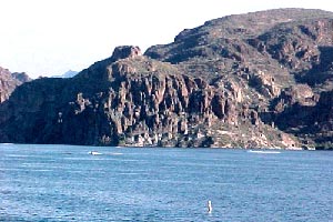
Field sampling sites included locations along the CAP and SRP canals and the Verde and Salt Rivers including Bartlett Lake, Saguaro Lake and Lake Pleasant (Table 1, Figure 1). Locations along canals, rivers, and water treatment plants throughout the Valley region were selected as sample sites in order to assess taste and odor problems throughout the entire water collection system. A multi-barrier approach will be taken to address taste and odor problems in drinking water supplies. Sample sites were selected to include locations along the entire water collection system in the Valley; from source water in rivers and lakes to finished water in water treatment plants. Water samples were collected monthly from August 1999 to June 2000 in the CAP, Verde River, Salt River, and SRP sample clusters.
Table 1 – Description of sample sites
| site # | site description | Latitude | Longitude |
| CAP Canal Cluster | |||
| R1 | CAP canal above Waddell Canal | N33 46.893 | W112 17.174 |
| R2A | Lake Pleasant integrated sample | N33 51.105 | W112 16.213 |
| R2B | Lake Pleasant integrated sample | N33 51.105 | W112 16.213 |
| R3 | Waddell Canal | N33 47.897 | W112 15.422 |
| R4 | Cap Canal at 7th St. | N33 42.079 | W112 03.935 |
| R11 | CAP Canal at Cross-connect | N33 30.858 | W111 41.603 |
| Verde River Cluster | |||
| R5 | Verde River btwn Horseshoe and Bartlett | N33 57.620 | W111 42.280 |
| R6A | Bartlett Lake near outlet | N34 00.000 | W111 05.625 |
| R6B | Bartlett Lake near outlet | N34 00.000 | W111 05.625 |
| R7 | Verde River below Bartlett Lake | N33 50.304 | W111 38.595 |
| R20 | Verde River at Tangle (USGS) | ||
| Salt River Cluster | |||
| R8 | Salt River inlet to Saguaro Lake | N33 33.349 | W111 27.450 |
| R9A | Saguaro Lake near inlet | N33 34.053 | W111 32.229 |
| R9B | Saguaro Lake near inlet | N33 34.053 | W111 32.229 |
| R10 | Salt River below Saguaro (Blue Point Bridge) | N33 33.335 | W111 34.436 |
| SRP Canal Cluster | |||
| R12 | AZ Canal above CAP Cross-connect | N33 31.022 | W111 41.589 |
| R13 | AZ Canal below CAP Cross-connect | N33 30.941 | W111 42.023 |
| R14 | AZ Canal – Inlet to Squaw Peak WTP | ||
| R15 | Squaw Peak WTP treated water | ||
| R16 | AZ Canal – Inlet to Deer Valley WTP | ||
| R17 | Deer Valley WTP treated water | ||
| R18 | South Canal at Val Vista WTP | ||
| R19 | Val Vista WTP treated water | ||
| R21 | AZ Canal at Central | ||
| R22 | AZ Canal at 56th Street |
Figure 1 – Map of Sample Sites

MIB Data

Contour plot for MIB concentration as a function of sampling date and sampling site location
Milt Sommerfeld can be emailed at Milton.Sommerfeld@asu.edu
Larry Baker can be reached at
Baker Environmental Consulting
8001 Greenwood DriveMoundview, MN 55112
763-783-8227
bakerenv@earthlink.net
http://home.earthlink.net/~bakerenv/index.html